


7,6 km | 9,1 km-effort


Usuario


Aplicación GPS de excursión GRATIS
 SityTrail
IGN / Institutos geográficos
SityTrail World
El mundo es suyo
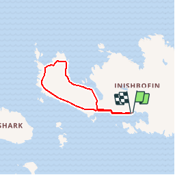
Ruta Senderismo de 8,1 km a descubrir en Desconocido, County Galway, Conamara Municipal District. Esta ruta ha sido propuesta por heb.
A-B. The loop starts from the pier in Bofin Harbour. Leaving the pier turn left and after 200m turn right at the first road junction. Ascend to reach a 4-way junction. Turn left here and join what is locally referred to as the ‘High Road’.B-C. Follow the road for 600m to reach a 3-way junction – you veer right here, joining a gravel track which takes you to a gateway. Cross the metal stile.C-D. Follow the stony roadway for 1km, passing through another gateway and crossing a stony embankment which separates Loch Bofin (on your left) from the Atlantic (on your right). At the end of the stone beach (North Beach)embankment, you rejoin a surfaced roadway. Turn right here.D-E. Continue along the roadway for 500m to reach a gateway – cross the stile here and follow the laneway and bog road along the rugged coastline around Westquarter. On your way you pass close to spectacular sea blowhole caves - a short detour to view it is well worthwhile, but do take care. Later you pass a monument overlooking 'The Stags', erected to the memory of American students who were tragically drowned off the coast in the 1970s. The loop then sweeps southward across open ground before joining a wonderful ‘green road’ below the ruins of a Promontory Fort, Dún Mór - highest cliffs on the island. E-A. The trip along the green road (South Road) provides spectacular views south to Inishark and the Galway mainland and eventually joins the ‘Low’ road along Bofin Harbour and back to the trailhead.Inishbofin lies 10km off the coast of County Galway in the west. The main activities on the island today are tourism, farming and fishing. There are five villages, West Quarter, Fawnmore, Middle Quarter, Cloonamore and Knock. This loop takes you on a trek around the western section of the island. For the adventurous the island is suitable for swimming, snorkeling, diving, shore angling, sea angling and hiking/hillwalking. Inishbofin has become an important centre for traditional Irish music and song and plays host to many visiting musicians and artists. The first documented history of the island dates from early Christian times. As you sail into the harbour you will notice Cromwell’s 16th Century Barracks which was used as a prison for catholic priests from all over the country after the English Statute of 1585 declared them guilty of high treason!

Senderismo